Tag Archives: Springbrook Nature Center

The Coon Rapids 10-mile bike loop makes it easy to connect and discover

by Russ Lowthian, HaveFunBiking.com

Named for the turbulent Mississippi River waters at the confluence of Coon Creek, the city of Coon Rapids is a fun place to explore on a bicycle. One of the nine communities in the Twin Cities Gateway, it’s a perfect destination for a bike vacation using the Coon Rapids 10-mile bike loop. Here you will find many connections to hundreds of miles of trails. The Coon Creek Trail and the Mississippi River Trail are two greenway systems here that allow you to pedal safely throughout the area. So, if you enjoy biking along rivers and creeks, we have some ideas for you, starting with the Coon Rapids 10-mile loop.

The 10-mile bike loop is fun for all levels of riders.

The Coon Rapids 10-mile bike loop

Leaving from the outer parking lot of the Muddy Cow Restaurant or a nearby hotel, the route travels in a clockwise direction. Pulling out onto Springbrook Drive, this tour safely crosses Coon Rapids Boulevard. Once across, we suggest using the paved trail that runs parallel to the street due to heavy traffic. After crossing 85th Avenue, about two miles into the loop, consider stopping at the Springbrook Nature Center.

Many roads here offer trails that parallel for added comfort and fun.

Now pedaling along the south side of 85th Avenue, at East River Road, cross the street at the stoplight and use the sidewalk on the west side, up to 85th Lane. Here enjoy the quiet neighborhood streets that connect you to the Mississippi River Trail (MRT).  At 86th Avenue, continue straight ahead on the MRT between two residences, and the real fun begins. Then, as the trail drops into the forested vegetation along the bank of the Mississippi River, it’s a whole new experience.

The visitors center here makes a great rest stop.

Following the trail along the river to the Coon Rapids Dam, you will pass several trail T’s in the park, offering more loop options. One loop in the park circles Cenaiko Lake where you will find many people fishing for trout.

The Coon Rapids Dam and Visitors Center

At the visitor’s center at the Coon Rapids Dam, you will find more information on the area and its history. The dam is another popular fishing location and a crossing point for cyclists riding the Three Rivers Trails throughout the Twin Cities Metro.

Riding across the Coon Rapids dam always offers a refreshing mist of cool air.

Turning north to Coon Creek

Riding up Egret Boulevard, you can ride in the bike lane or use the parallel pedestrian path.

Now at the Dam, the 10-mile Loop leaves the MRT and heads north out of the park on Egret Boulevard. You can ride the designated bike lane or use the pedestrian path paralleling the street on a bike-friendly road. Continuing north after crossing Coon Rapids Boulevard, at Robinson Drive, you will find the Coon Creek Trailhead. On the trail and after crossing the creek, the 10-mile loop takes a right at the trail T. If you want to add a few miles to your ride, here is another option. To your left, the trail will take you up through the Erlandson Nature Center and, further along, connects to Bunker Hills Regional Park.

The smells, sounds, and views of nature as you pedal

Now pedaling south alongside Coon Creek, enjoy the smells, sounds, and views of nature. This stretch of the trail is a tranquil wilderness setting as you pedal along the stream through the forested canopy.  After crossing over a creek bridge one more time, pass under the railroad tracks for another option. Stop for a round of bumper boats, go-karts, or miniature golf at Lilli Putt before heading east and completing the 10-mile Loop.

Enjoy the smells, sounds, and views of nature along the trail.

The trail runs parallel along Coon Rapids Extension and Boulevard for the last few miles of the route. Back at the parking lot, or your hotel, check out nearby eating establishments and plan another bike adventure in the Twin Cities Gateway Area.

Printable map and Q (cue)-sheet)

For a printable bike map of Anoka, click here

For a turn-by-turn Q-sheet of Anoka, click here

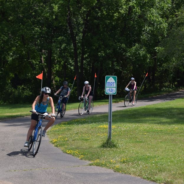
The Fridley 10-mile bike loop lets visitors discover the MRT

by Russ Lowthian, HaveFunBiking.com

Named for an early settler along the east bank of the Mississippi River. Today bike-friendly Fridley, with its 10-mile bike loop, lets visitors discover art, nature, and beautiful flower gardens along the way. Here, with many cycling paths connecting to both the Mississippi River Trail (MRT) and the Rice Creek Trail, it’s easy to get around. One of the nine communities of the Twin Cities Gateway, the city of Fridley is located just north of Minneapolis and a fun place to explore. So, if you enjoy biking along the trails that Red River oxen carts once used, we have some options to explore while enjoying the Fridley 10-mile bike loop.

Fun on the Fridley 10-mile bike loop.

The Fridley 10-mile bike loop

Starting from the outer parking lot of the LivINN Hotel, (southeast corner od I-694 and Central Avenue) the Fridley route heads out in a clockwise direction. After crossing the intersection at Central Ave. drive your bike using the bike lane on 53rd Avenue for the next two miles. Now turning to the north on Main Street, once over Interstate I-694, you will pass Woodsprings Hotel. Those who would like to begin the 10-mile bike loop from this point continue north up to 61st Avenue. Here on your left, you are at the Fridley train station.

Passing through Edgewater Garden Park on the MRT.

Taking the tunnel under the RR tracks

On the east side of the Northstar-Line Fridley Station, use the elevator. Taking your bike with you down to the lower level and walk through the tunnel to the west side of the train tracks. On the main level, on the west side, the Mississippi River Trail (MRT) is right outside the door and ready for you to venture north again. An option for another day, consider boarding the Northstar Train with your bike and ride it up the Anoka, Elk River, or Big Lake, then pedal back to Fridley on the MRT. See the multi-modal train-to-trail cue sheet here.

Many roads in Fridley offer trails that parallel for added comfort.

More adventure awaits at the Locke Lake trail T

Flower gardens invite you into the Banfill-Locke Center for the Arts.

Back on the 10-mile bike loop, continue pedaling north on the MRT as the trail passes through Edgewater Garden Park. A little further on, before turning into Locke Lake Park at the trail T, you have a couple more options. If you don’t mind adding some additional miles out and back, continue on the MRT to the Banfill-Locke Center for the Arts. With rotating art exhibits, the art center is next to Manomin County Park. Another mile further, you will find the Springbrook Nature Center. These three community highlights can add more memorable moments to any bike ride.

Manomin County Park is on the same grounds as the Banfill-Locke Center for the Arts.

Back on the 10-mile bike loop, the trail connects to the Rice Creek Trail in Locke Lake Park. Use caution as you ride your bike through this area. You will need to apply both your front and rear brakes (or walk your bike) as you descend along Locke Lake on the trail. If you are riding with others, allow extra space between each, as a few sharp turns are passing under the RR tracks next to Rice Creek as it flows into the lake. Finally, at the next T, the Rice Creek Trail runs through Fridley Community Park.

Now riding east along the Rice Creek Trail.

After crossing University Avenue, at the stoplight, resume riding east on the Rice Creek Trail. In this section between University and Highway 65, the Rice Lake Trail offers an upper and lower trail segment. The 10-mile loop uses the upper trail, as it’s a bit shorter and takes you past restroom facilities in the park before reaching the tunnel under Highway 65. After the tunnel, resume the route by taking a left at the trail T to Central Ave. If you are staying at Budget Host Hotel or desire to start the 10-mile loop from here, at this trail T take a right and head south a block to the hotel.

Turning south, ice cream may soon be an option.

The trail route now, heading south, runs parallel to Central Avenue. If you have a sweet tooth and desire a delicious Ice cream treat, turn right on Moore Lake Road into Grandpa’s Ice Cream.

The flavors here are worth stopping for.

Continuing along Central Ave, as you reach Hillcrest Drive, you have one more option to cool off. If it’s a hot day, half-mile further south is Moore Lake Park, where you will find a beach for a refreshing swim. Otherwise, take a left on Hillcrest, and the route jogs through several neighborhood streets down to Matterhorn Drive. After crossing over Interstate 694, turn right on Skywood Lane and follow the freeway border wall around to the start.

Back at the parking lot or your Fridley hotel, check out the nearby eating establishments and plan another bike adventure in the Twin Cities Gateway Area.

Printable map and Q (cue)-sheet)

For a printable bike map of Fridley, click here

For a turn-by-turn Q-sheet of Fridley, click here